Sunday, July 21, 2013

Day 9


            Well this bike ride on the Great Allegheny Passage and the C & O Canal is “in the history books”. We had a nine hour ride home and arrived safely about 5 PM. Of course, the weather today would have been perfect for biking, because we were not biking. The temperature was in the low 80’s, not the high 90’s we had been experiencing.

            We all had such a good time and blended together as a cohesive group of friends, even though we mostly did not know each other before the trip. Carol and I hope to offer an even better trip next year to benefit Rails-to-Trails of Wayne County, as this was a learning experience for us. These wonderful people were our “guinea pigs”. You as the reader might want to give consideration to whether you would be interested in this ride. Here are a couple pictures.

Bikes and luggage are unloaded and in each person's car,
as we say our "Good Byes".
 

Poster with pictures of all 186
mile markers along the Canal
from 0 to 184.5
 
THE END.

Saturday, July 20, 2013

Day 8


            Well our trip is over and we were each successful in completing our goal. We left at 8 AM in 2 shifts to be transported back to Whites Ferry from Leesburg (7 miles). We were underway by 9 AM. It was overcast for awhile (cooler) but then the sun came out. There was a slight breeze art times though. This was a 35 mile day with the last 22 miles with water in the canal. There were more and larger mud puddles this morning with gravel this afternoon, at times somewhat rough. And Tess fell once coming down an incline at a lock, where there was suddenly deep gravel, but with no injuries. The GAP has a better surface than the C&O. Lunch was at the Great Falls Visitors Center snack stand in the parking lot. After lunch, we walked out the trail to see the Great Falls up closer. Then we rode on into Georgetown. We arrived at the zero mile marker for the canal after 3:00 PM. Then we spent some time taking pictures of couples and the whole group at the zero marker. There was a slight chance of rain today but we did not get any today or all week. The hot weather was hard on us but lots of rain would have been worse.

            Some are glad they completed it but once was enough and some are considering the possibility of doing it again sometime, but I think all agree it is “the ride of your life” and quite an accomplishment to be proud of. I have learned a lot this trip and the trip will only get better. The group agrees that my wife Carol (who delivers cold water and luggage service) is the REAL queen of the ride.  Tomorrow we have an all day drive home. I hope to be able to lead a group again  next year and perhaps YOU the reader, would be interested in doing this ride.

Taking the van and trailer back across the Potomac River at Whites Ferry.


Visitors Center at Great Falls.


Mather Gorge at Great Falls.


Widewater, just below Great Falls.


A rest stop. Jenny and Bob are in front.


Our group at C&O sign in Georgetown.
JD, Jan, Gary, Tess (front), Dean, Deb, Lee (behind), Jenny and Bob.


The zero mile marker at the guard lock, where the canal and Rock Creek
dump into the Potomac River.
Front-Keith and Tess.
1st row-Deb, Jan, Gary, and JD.
Back row-Lee, Jenny, Bob and Dean.

Friday, July 19, 2013

Day 7

Harpers Ferry, as seen from the Towpath.


Spiral stairs up to the bridge,
on the side of the RR bridge.
Our bikes are locked below.


Pedestrian walkway beside the railroad,
going across the Potomac River,
to Harpers Ferry.
Jan, Bob and Jenny.
 

"Flat Stanley" visits Harpers Ferry.
 

John Brown's "fort"
(the fire engine house).
 

Monoacy Aqueduct, the longest aqueduct on the C&O.
   

The General Jubal Early (the ferry boat at Whites Ferry.
It is the last operating ferry on the Potomac River.
 

Carol, with the bike trailer and a load of people.
 

Gary's new bike (with a kick stand).
(He doesn't like kickstands).
 
 
            You may not think of bicycling as a “team” sport but our trip surely is a team effort. Some of the group has had concerns about whether or not they could complete the trip. It is a long distance, the weather is hot, some could have used more training but didn’t have time, and have I said we are hot and tired every day? But when the “chips are down” the group will do whatever it takes, to make sure everyone will finish. If we have to stop more often so some can rest, they do it. If we are hot, tired and low on water. Carol shows up with a cooler full of cold water. But this morning, was the “kick when you are down”.
            Despite already having more than enough pain already, this morning I went out to the bike trailer with the bikes locked, to find two bikes stolen. Gary and Jan’s bikes were gone. They were locked together but not to the trailer, making them the easiest one to steal. They had removed some of the tarp straps we use to align the bikes, but the others were locked in larger groups or to the trailer. So we called the police and made a report.
            At supper yesterday, we had decided to get up early and drive several of the fellows thru the Antietam battlefield, since we were very near to it, before starting to bike. So that plan went out the window. We were carrying Carol’s bike as an extra, in case of trouble, and this was trouble. So I told Jan to take Carol’s and Gary to take mine. Gary would not hear of it. He would not accept riding if it meant I couldn’t. Next we considered renting him a bike for 2-3 days, but the local bike shop did not open till noon. Then we started thinking, where could we get a cheap bike? Pawn shop? Then we hit on Wal-Mart. So I drove Gary and Jan to Wal-Mart to look at bikes. They had some that were “returned” and had to be sold as “used” (35% off). So he found a “no-name” mountain bike that fit him and bought it. By 9:30 AM we were ready to drive down to the parking lot where had quit the day before, only to find that Dean had another flat tire. So we took a load down to the parking lot and repaired the flat, while Carol brought the second load of people and luggage. There was never any question of Gary and Jan NOT riding with us; we all did whatever needed to be done, to make the ride together, so ALL could reach their goal of completing the ride.
We started at 10 AM but we were all soaked with sweat before we left the parking lot, just from unloading the bikes, loading the luggage and putting in Dean’s new tube (it was the yesterday patch that was leaking).
            We arrived at Harpers Ferry and locked all the bikes up on the Maryland side (of the river) and walked across the river to see the town (West Virginia side). We decided to eat lunch first, as it was noon. Then we spent 45 minutes to an hour seeing part of the history displays. For those who don’t remember their history, John Brown, with 20 others, tried to raid the Federal arsenal (where the army’s guns were made and stored) to have guns to help the slaves overthrow their owners. He was captured and “hung” a month later for treason.
            It was so hot that walking around Harpers Ferry was more work than riding bicycles under the trees (as most of the towpath is). Carol met us at Brunswick with a cooler full of cold water, which couldn’t have been more welcome. She then drove to the hotel and unloaded all the luggage before driving out to Whites Ferry to shuttle us (2 trips in rush hour traffic) the 7 miles to the hotel in Leesburg, VA, the only town where lodging is available between Brunswick and DC.
            Gary’s bike is not great, as the shifting is pretty rough (probably why it was returned) but it will get him to Washington. We walked to a Mexican restaurant for supper. We are all expecting to lose a few pounds this week, despite eating a lot, just because we are exercising so much (riding all day long). Tomorrow is our last day of riding and while it has been hot and hard, I think people are “savoring” the possibility of completing their goal. Yes, the bikes are all safe in our rooms tonight.


Thursday, July 18, 2013

Day 6


            We left at 7:30 AM again this morning because we had a 52 mile day. The group has really “gelled” into very close friendships. We can joke with each other and tease each other with no hard feelings.

            Dean started to notice he had a soft tire and we stopped to pump it up twice before lunch. We rode into Williamsport for lunch and there was a group of volunteers at the Visitors Center, working on bikes. Dean asked if he could pay them to repair his tire but they said no, they could not take cash. They were setting a group of “trail rangers” who would ride (patrol) the towpath in the area and answer questions and “help out” as needed, if there were bike problems and he was given an email address, if he wanted to write an email in support of their proposal. So I asked if they would adjust my rear shifter, while I walked up town to eat lunch with our group. They said they would.

We ate at the Desert Rose CafĂ© and it was very good. After lunch, we started out for Shepherdstown. In an hour, my patch from yesterday was leaking and I flatted. Since that tube already had 2 patches on it, I put in a new tube. We started out again and rode through the Big Slackwater (where after decades of no towpath), they completed the 2 miles of “missing” towpath, almost 2 years ago.     When we arrived at Dam No. 4, we took some pictures and rested. Then there was a short, steep, very rocky descent to the towpath and at the bottom, Lee had a flat tire. The last 5 of us were together and stopped to help. Lee has been putting air in it most mornings, so it finally failed on the rocky ride down. We all got on our bikes to leave and I had another flat (from the rocks). So we started over and took mine apart. It was a long cut and may have been pinched when it put in the new tube a short time before and the rocks were too much for it. So we tried to patch it TWICE but each time it did not hold till we got it back on the bike. So I had ONE more spare tube with me and we decided to chance it and I put it in. It is working well now. I hope I can find another spare tube before I need it.

            Carol had already delivered the first 4 people to the hotel and we arrived at the pickup point an hour later than them. (That was how long it took us to repair Lee’s and my tires.) We here hot, tired and late (5:45) and set supper at 6:45. The first two restaurants were a long wait (for 13 people). JD’s brother drove down from PA to visit him and go out with us for supper, so we were a larger group than normal.  So supper was at a Chinese restaurant tonight.

This is what most of the C&O Canal Towpath looks like.
There are 2 tire tracks from the ranger's vehicles.
 

We passed Fort Frederick, a Revolutionary War Fort,
That is now a MD State Park.
 

This area is called Four Locks. There are 4 locks in close secession.
You can see 2 of them in this picture.
 

Little Slackwater, where the canal boats were out in the Potomac
River for about 3/4 of a mile and the Towpath is on a rock ledge.
Dean and Tess are just riding out onto the rock ledge.
The view is beautiful.
 

Dam No. 5 that backs up the river to provide
navigation for the canal boats in the Potomac River.
 

Cushwa Basin. Formerly where some of the canal boats
unloaded coal coming from Cumberland.
It is now a NPS Visitors Center.
 

Bob is coming out onto Big Slackwater, a 3-4 mile
long area where Dam No 4 holds water,
because there was no room to build a canal between
 the Potomac and the side of the mountain.
 

Part of the new two mile concrete section of the
towpath at Big Slackwater.
This also is a very beautiful area to ride.
 

Dam No. 4 below Big Slackwater.
 

Lee and Bob repairing Lee's flat.
 

Wednesday, July 17, 2013

Day 5


            Today was our long day- 60 miles. We had breakfast at 6:30 and left at 7:30 to get an early start and beat the heat. It didn’t work. It was already hot and humid when we left. About 10 miles out, I noticed my rear tire was very soft. Finally I had to stop and pump it up. Then it was every 4 ½-5 miles it needed air. I put air in it probably 4-5 times before lunch. Lunch was to be in Paw Paw, WV, just across the river from the Paw Paw Canal Tunnel. Carol was to check on whether there was a restaurant or just a convenience store. The pizza shop did not open until later so she bought some sub sandwiches and brought then to the parking lot at the tunnel, rather than shuttle us (in 2 trips) the one mile into town. So while everyone ate, I repaired my rear tire.

            I removed the tube and put air in it. As I looked around the outside of the tube, I saw a hole with a circle “chalked” around it. I lined it up with the tire to find out what punctured it, and inside the tire, there was a hole in the tire with a circle “chalked” around it. When I pinched the tire, I could see a piece of glass which I picked out with my knife. Now I have not had that tire off in several years, but the mystery is, why would I mark it and not fix it and why, after years and 150 miles in the last 4 days, would it suddenly start to leak. Anyway, I patched it and it has been fine the rest of the day.

            We had 30 mile till lunch this morning and then 15 miles till Bill’s Place (afternoon break), the ONLY other to get anything to eat or drink all day. We had lunch at 11 and break about 2:30. The towpath was fairly rough (unlike the GAP Trail) but was surprisingly dry, given all the rain they had a week ago (like Ohio).  We had feared the worst, but each time there was a puddle, there was a dry spot to ride across it. Five miles after Bill’s Place, we arrived at the end of the Western Maryland Rail Trail, which parallels the Towpath. Then it was 13 miles of asphalt pavement downhill to Hancock, and our overnight stop. We arrived at 5 PM. Carol shuttled us (2 trips) to the Super 8 Motel at the edge of town; After showers, we ate at Weavers Restaurant, a well known local restaurant. The heat was very tough and stopping to rest every so often, was very hot but we needed breaks, even if stopping was hotter than riding. When you ride you get a 10 mile an hour breeze. But we all feel heat is better than rain all day. We are tired and ready for bed.

Our group at the 184 1/2 mile marker on the Canal.
Zero mile marker will be in DC.
LF. Jan, Gary, Tess, Deb, and JD.
2nd row-Dean, Lee, Jenny and Bob.
 

Here we are at a very unusual site. It is an interstate (goes from MD to WV), 
 low water (you can not cross when the water is high),
privately owned ( not government)
toll bridge.
 

Keith, patching his bike tube, in the parking lot of the Paw Paw Tunnel.
 

Our group, in front of the west end of the Paw Paw Tunnel.


Bill's Place
Bar, restaurant, bait shop, grocery, canoe rental, Mayor's office, etc. in Little Orleans, MD.
 

Jenny, soaking up the cold air from the AC unit above the door at Bills.
 

Little Orleans Directory.
If it's not at Bill's Place, it isn't in Little Orleans.
 

Starting on the Western Maryland Rail Trail.
 

Temperature at Hancock when we arrived.
(Actually it was probably only 97 degrees.)

Tuesday, July 16, 2013

Day 4


            Well I finally got “my act” together. No, that’s not an accurate statement; just ask any of our group. Since I FINALLY got high-speed internet service, I went back and “edited” the last two days and added pictures and captions, so check them out.

            Last night everyone (but Carol and I) were in Bed & Breakfasts. They both served breakfast at 8:00 and we all started riding at 8:45 AM and rode together all day.

            We had 20 miles of upgrade to the high point, The Eastern Continental Divide. Water behind us (after arriving) flows to the Gulf of Mexico (by way of the Ohio and Mississippi Rivers). Water in front of us flows to the Atlantic Ocean (by way of the Potomac River), but I am ahead of myself.

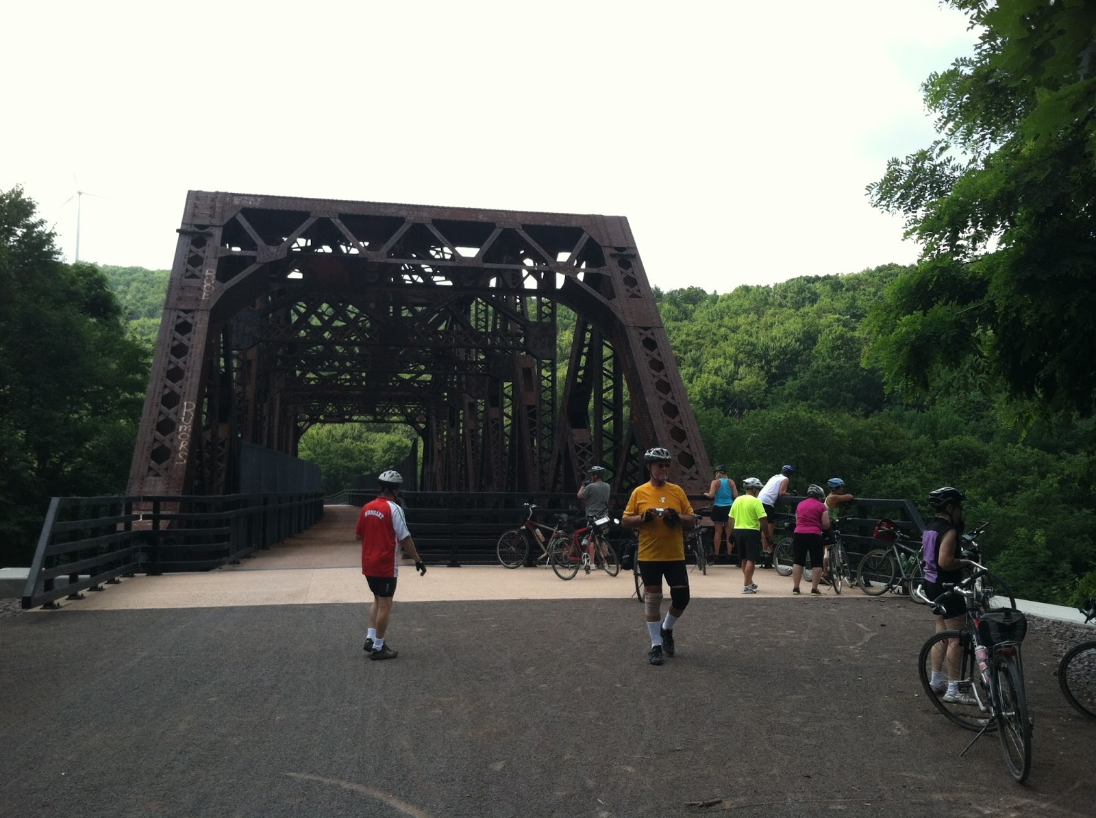
            First, we arrived at the Salisbury Viaduct, a 1900 ft. long bridge that is 101 feet above the valley. It crosses the Casselman River, CSX RR, US 219 bypass and old 219. It is one of two “signature” structures on the GAP. Two miles later, we arrived at the depot in Myersdale, PA (water, restrooms and shirts for sale). Next is the Bollman Bridge, is a beautiful old historic wrought iron bridge that was moved from near Meyersdale to replace a dangerous county road tunnel under the trail.

The next rest stop/picture opportunity was at the Keystone Viaduct, a long, curved bridge over the valley and CSX RR. Next was Deal, where the donor plaque honoring the persons, groups and businesses that had donated money to help refurbish the Big Savage Tunnel. (It is a ¾ mile long lighted former WM RR tunnel that cost $12 million to restore.) There was “extra credit” given, if you could find Rails-to-Trails of Wayne County, Ohio’s name on the donor’s plaque. Yes it is there! Soon (noon) we were at the Eastern Continental Divide for more pictures. (Any excuse to take a break on an upgrade on a hot day. From here, the trip is all DOWNHILL! In 2 miles we were at the (lighted) Big Savage Tunnel and were able to enjoy a long cool ride thru. The Big Savage is the other famous structure on the GAP. Then just out of the tunnel we took pictures of the “narrows” where Cumberland is at the end. It is perhaps 14 miles “as the crow flies” but 20 miles, as the trail follows the side of the mountain around the long way.

Now it was 20 miles of downhill to Cumberland. If you pedaled slightly, you were going 12-13 miles per hour. If you pedaled steadily (as we were) you went 15-16 miles an hour. On the way down, we went thru Borden Tunnel unlighted but fairly short), stopped at the trailhead for Frostburg, and went thru Brush Tunnel (lighted and shared with the tourist railroad the goes from Cumberland to Frostburg). The train runs Thurs, Fri, Sat and Sunday.

It had taken us 3 ½ hours to the top (22 miles) and only 2 ½ hours down (22 miles). We were flying. We were at the hotel by 2:30 in the afternoon. The pool was one option, as well as the C&O Visitors Center and an optional ride on a short railtrail just below Cumberland, though relaxing probably was the “main event”. We had chosen to only eat energy bars for lunch, since the options were ride down into Meyersdale and then UP after lunch or UP at Frostburg and then back down to the trail. So we opted for fewer miles and no more climbs, instead of lunch. Some at lunch soon after arriving and cleaning up and some just ate an early supper. Everyone was glad for the downhill and to arrive early.

Ready to leave Rockwood.
 

Dean's sign- "DC or BUST"
 

Arriving at the Salisbury Viaduct.
 

Flat Stanley gets to see the Salisbury Viaduct.
 

Lee and Deb on the Viaduct.
 

Other end-JD, Lee, Dean and Deb.
 

Meyersdale Depot.
 

Keystone Viaduct.
 

BIG savage donors plaque at Deal.
 

The Eastern Continental Divide.
 

Depiction of the elevation-"you are here"
See the red arrow at the top.


Arriving at the Big Savage Tunnel"
 

Riding thru the Big Savage.


Cumberland is just beyond the valley in the center of the picture,
but the trail goes to the right out of the picture.
 

Bob and Jenny at the Mason/Dixon Line,
the boundary between Pennsylvania (behind me) and Maryland (behind them).
Mason and Dixon were the surveyors who established the "line"
which settled the dispute between PA & MD over the boundary. 
 

Brush Tunnel, shared with the scenic railroad.
 

Zero mile marker for the GAP.
GAP is at the top of the picture.
The C&O Canal Trail starts at the bottom of the picture.
 
 
WOW! We saw a lot of things today. On to the C&O tomorrow.