Monday, July 15, 2013

Day 3


Two groups started at different times. The early group planned on 6:30 AM but got out at about 7:30. The latter group planned on 8:30 but started about 9:00. It was a beautiful morning and we all started out strong. Since I was not in the early group, I can’t tell you much about them except they had lunch at Sisters Café in Confluence and arrived about 3:30 and the other group arrived at 5:15. The second group stopped at Ohiopyle to look at the (water) falls and then rode on to Confluence for lunch at 1:00 PM. We ate at the Lucky Dog Café, which is right on the trail, rather than riding into town to Sisters Café. Connellsville to Ohiopyle is a slight up grade but we were fresh. Ohiopyle to Confluence is a little flatter, while still climbing a little. From Confluence to Rockwood was more grade (reportedly only .7%) but with a longer day than the last two (supposed to be 44-45 miles) in the 84 degree temperature, after 5 hours of riding was tiring us all and we took frequent rest breaks (every 5 miles or so at the end). Apparently the mileage on the charts and maps does not include the 2 miles around the Pinkerton tunnel which is closed. The good news was, the 2 miles around the tunnel were flat, not uphill.

Some of the people are staying at the Rockwood Trail House (B&B) and some at the Gingerbread House (B&B). Carol and I are staying at the Hostel on Main. For supper we were going to the Rockwood Café but found out it is closed on Mondays. Then we were going to the Laundromat, only to find out it was out of business. AH, the joys of travel. One B&B has a laundry and our Hostel has one, so we are on “Plan B”.

"Flat Stanley" (from the Orrville Public Library-Summer Reading Program)
joined us on the trip. He "came out of hiding" on the first day, but this is the
first picture of him, in the blog. Bob and Jenny are "transporting" him and he makes an appearance, every so often. Jenny will tell about his travels, when she returns home.
 

This is the Bowstring Bridge, that the Ohiopyle State Park had designed
 and built, to cross the Yough River in Ohiopyle.
 

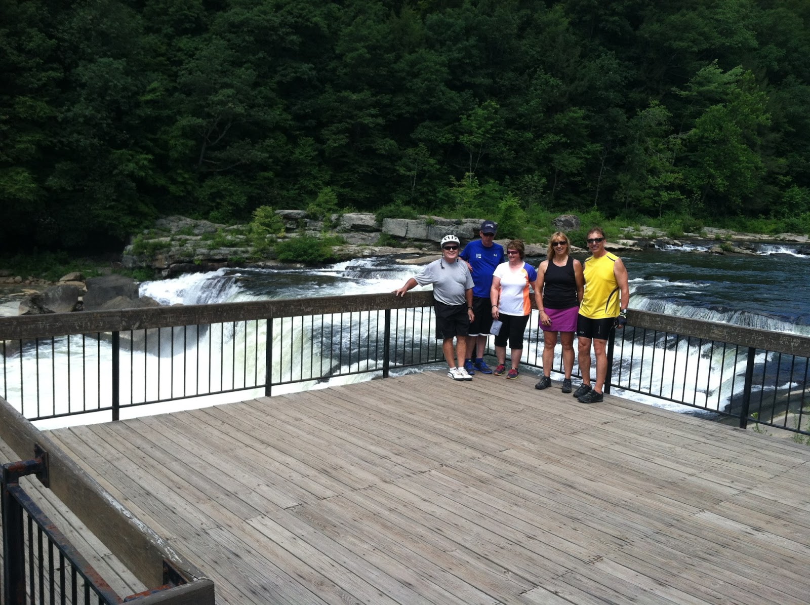
JD, Lee, Deb, Jenny and Bob, at the Falls in Ohiopyle.
 

A side view of the Bowstring Bridge.
 

We are on the Pinkerton High Bridge. (The Pinkerton Low Bridge
is on the other side of the tunnel straight ahead).
The "cut" and excavation just to the left, was the CSX RR's
Pinkerton Tunnel. They "day lighted" it (removed the top of the tunnel),
so they could run double stack trains (very high railroad cars)
through where the former tunnel was. (The Western Maryland RR Tunnel
is straight ahead).
 

CSX former tunnel to the left.
Western Maryland (now) unsafe tunnel closed.
The Great Allegheny Passage turns right and follows the river around the
"peninsula"of land, while the rock from above the CSX RR Tunnel, was dumped
above the WM tunnel and to the right in the picture.
 

Picture of the interior of the (unsafe) Western Maryland
RR Tunnel, as I peeked through a crack in the fence.


Second group after arriving at Rockwood. It was uphill all day.
JD, Jenny, Keith, Bob, Deb and Lee.
The other group arrived earlier.
 
Terrible internet service and “pictures” are still giving me fits, mostly because there is slow service here. I will quit for tonight. Should be good service in Cumberland tomorrow night.

Sunday, July 14, 2013

Day 2


          Well our B&B was quite a night last night. Our Innkeeper was Lin. She was a “hoot”. Her decorating was very different. Each room had a “Theme”. But she said a couple things you don’t want to hear your innkeeper say.

She said “Have you seen the outhouse door?” (Meaning what it looked like-it was a very primitive door that someone had discarded) and she said “When I am around disturbed people, they feel sane”. (Yes she was a “nut”). We had quite a time with her. Half the group stayed with Lin at the Yough Shore Inn and half at Trailside Treasures.

This morning, we let people ride at their own pace; since the trail east of Boston is pretty much a “no brainer”-you can’t get lost (Pittsburgh to Boston is not marked clearly in some places, but getting better). We basically had a group that rode faster and stopped less and a group of the opposite.

The first problem we encountered was a mud slide from the same rain storm that we had in Ohio last Wednesday. Close to 100 feet of trail length was covered with an inch of very wet mud, when the deluge plugged a drain under the trail. The first people walked and pushed their bikes thru it (it was too slippery to chance riding thru it) but by the time the last of us arrived behind Bob and Jenny, they instructed us to carry our bikes. That way only your shoes got muddy (they would anyway) but not your bike and tires. That was really the only trouble we had (not counting the 88 degree temperatures in the afternoon). The rest of the trail surface (crushed limestone) was excellent-dry and hard.

Dean, Tess, Gary and Janet arrived at the pickup point at 2:30 and got shuttled to the motel, The Melody Motor Inn. It is a 1950’s mom and pop motel, not plush but very adequate. Bob and Jenny arrived at 3:30 and Lee, Deb, JD and I arrived at 4:00. There was a “bonus ride” offered on the 2 ¼ mile long Sheepskin Trail that connects to the GAP, 2 miles beyond Connellsville. Lee and Deb “opted out” and went to the motel but Bob, Jenny, JD and I rode it and got picked up at the end of the Sheepskin in Dunbar. The mileage today was about 39 miles and the extra ride added about 5 miles. Tomorrow’s mileage is about 45 miles, so it made more sense to do it today, if you wanted to do it.

Since we rode late, we got cleaned up late and ate late. We went to Bud Murphy’s Sports Bar. It was good food, reasonable prices, lots of food and “The” busiest restaurant in town. Several of the group recommended it as they had eaten there before and said it was also busy when they had been there.

Tomorrow the “climb” is more than the last 2 days with something like 900 feet. It is not steep but a steady climb and more height than we have experienced yet. We will go thru Ohiopyle (where the white water rafting is done) to Rockwood.   

The Cowboy Room at the Yough Shore Inn
 
 
The Las Vegas Room
 
Ok, my photos are not cooperating and I am tired so I am quitting for tonight.
 
What happens on the bike trip, stays on the bike trip.
 

Our group leaving the Yough Shore Inn;
L-R (front) JD, Carol (our support), Deb,
(back row) Keith & Lee.
 

Keith at the "Red Waterfall" (It's AMD-acid mine drainage,
from a former coal mine). 

"On the Trail"-West Newton-4, Connellsville-29,
Ohiopyle-46, Cumberland-120, Washington DC-304.
 

Keith, Lee, Deb, & JD at West Newton Depot.
 

Keith at Connellsville Park sign.
Washington DC-280 miles.
 

The whole group at supper at Bud Murphy's Sports Bar ,
Sunday evening. 
 

Saturday, July 13, 2013

Day 1


            Well we left this morning at about 9:15 AM, after we got the bikes loaded. We had a van and driver, deliver us to Southside near downtown Pittsburgh, across the Monongahela River from “The Point” where the Mon (for short) and the Allegheny Rivers meet to form the Ohio River. We had stopped for lunch shortly before arriving and were ready to ride by1:15 PM.

            Each of the nine riders (or couples) gave a little bio about themselves, which I will share now. All are from the Wayne/Holmes County area.

            Jan B. is retired from nursing. “I’ve been riding for 20 years and I rode GOBA twice           Today we crossed the Mon River and then the Yough (Youghiogheny) River and will follow the Yough for several days. Here are some pictures from today. . Besides biking, I play table tennis and ski.”

            Gary B. is retired. “I now spend my time playing table tennis, skiing, biking and playing cards. We have four cats and 6 grandchildren.”

            J.D. Milliken retired from J M Smucker Co. 6 years ago after 34 years with them. “I live in Wooster with my wife Arlene and when not spending winters in Florida, play golf, in addition to bicycling and visiting our two married daughters and their families in Columbus. We have two grandsons (ages 6 and 9) who play baseball.”

            Lee and Deb Miller live in Berlin. Lee works at The Commercial & Savings Bank in Millersburg and Deb works in the surgery area of The Wooster Eye Center in Wooster. “We have only been biking a few years but really enjoy rail-trails.”

            Bob and Jenny Brooker are both teachers; Bob at Dalton Intermediate and Jenny at Orrville Middle School. Bob is currently in his 14th year as mayor of Marshallville and Jen is serving in her 2nd year as secretary of RTWC. “We love to do all things active and love to travel.”

            Dean and Tess Cooper are retired and living near Wooster. “This is our first type of biking experience. Hopefully we will survive to tell our future grandchildren.”

            Keith and Carol live outside Orrville. Carol is a retired Green Local Schools cook and Keith is a retired toolmaker from Will-Burt Co. in Orrville. We enjoy riding rail trails and have ridden many around the US. We first rode the C&O 25 years ago and when Keith found out about the proposed long distance trail from Cumberland toward, he started exploring it 20 years ago before much of it was open.  

            So that is our group of riders. Today we rode 20 miles to the town of Boston, PA and are staying in bed & breakfast type lodging tonight. Carol brought our van pulling the trailer with all the bikes loaded on it. She also shuttles us to our lodging and then the restaurant at night, if we are not close to the trail or the road is dangerous.

            The trail out of Pittsburgh is now (FINALLY) open but has a few places where it is not well marked, so having a map or guide to show the way is helpful. It is improving though and an improvement from 2 years ago when I did this ride.

           Today we crossed the Mon River and then the Yough (Youghiogheny) River and will follow the Yough for several days. Here are some pictures from today.

Our group, ready to leave.

                     This is the trailer load of bikes. They hang from the front wheel of each bike.


Here we are in Pittsburgh, ready to start our ride.
 
 
"The Point" across the Mon River. That's the Allegheny on the left side and to the far left, out of the picture, is the Ohio River.
 

At the end of the day, arriving in Boston, PA.
 

Thursday, July 11, 2013

The Ride of Your Life

Riding the GAP and the C&O is "The Ride of Your Life"!


This is a group ride on the Great Allegheny Passage and C&O Canal, from Pittsburgh, PA to Washington, DC. It is to benefit Rails-to-Trails of Wayne County, Ohio. It is from July 13 to July 21, 2013 and is an "indoor lodging" trip. It will average 45 miles of riding a day, for 8 days.


Pictured at the left, is the Salisbury Viaduct (former Western Maryland RR bridge); a 3/4 mile long bridge across the Casselman River, US 219, the CSX Railroad and the valley.


This is a map of the completely "off road" bike trail, from Pittsburgh (left) to DC (right). I (Keith Workman) rode it in 2011 and am leading this group of 9 other riders. (The Salisbury Viaduct is pictured at the bottom of the map.)


This is a representation of the elevations on the ride. The combined trails are 335 miles long. The C&O is 185 from Washington, DC to Cumberland, MD and the GAP is 150 miles from Cumberland to Pittsburgh. The last uncompleted section near Pittsburgh, opened June 2013. The long standing road detour on the C&O was removed in Sept 2012, when Big Slackwater section of the Towpath was opened to travelers. The "grade" is not as steep as it looks, because the bottom scale (125-325 showing) is in miles and the vertical scale is in feet (to 2392 ft.). That's only 1.7 % grade, at the steepest part. In this "view" DC is on the left and Pittsburgh on the right.


This sign is in Cumberland MD where both trails meet.


"Patch" for the GAP.


"Patch" for the C&O.


Follow our travels each day, we experience "the ride of our lives".  The trail goes "thru the mountains, not over them as the GAP Trail goes thru three tunnels, the longest of which is the Big Savage Tunnel at 3300 feet long (that's almost 2/3 of a mile long, but it is lighted).
Hope you enjoy our trip as much as we expect to.